From Concept to Keepsake: Illustrated Maps That Guests Really Want to Take Home
Maps don’t have to be boring. In fact, the best ones are part guide, part work of art, and part “I’m taking this home with me” souvenir.
For me, illustrated maps are where storytelling meets wayfinding — a chance to capture the spirit of a place, help people explore it, and create something beautiful they’ll want to frame, fold into a suitcase, or post on their fridge when they get home.
Whether it’s guiding guests to the perfect wedding spot at Camp Lucy, highlighting the boating lifestyle for Brunswick Boat Group, or mapping out Savannah’s historic charm, each project starts with the same question:
How can this map make the experience more memorable?


Step 1: Research Like a Local (Even if You’re Not)
Before pen ever hits paper (or stylus hits tablet), I dive deep:
Studying site plans, aerial views, and Google Street View
Digging through brand guidelines
Collecting reference photos of key landmarks, architectural details, and local icons
Sometimes walking the property if possible — or doing the next best thing, which is spending way too much time virtually “wandering” on Google Maps
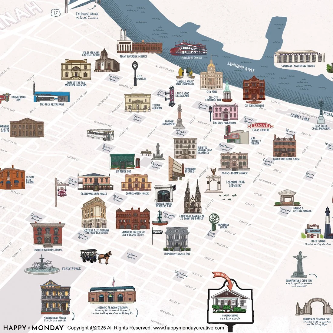
For my Savannah illustrated map, it meant finding the sweet spot between accurate navigation and charming visual storytelling. Think Spanish moss, iconic squares, and a color palette that feels like the city at golden hour.
Step 2: Sketch the Story
This is where I figure out the visual “flow.” Guests don’t need every detail, but they do need the right ones in the right order.
What’s a must-have landmark?
How do we simplify the layout without losing character?
Where can we sneak in little easter eggs for guests to discover?
The Camp Lucy resort map started as a pencil sketch over the property layout, with trails, event spaces, and lodging marked for easy wayfinding. Layer in some upscale-rustic styling, and suddenly it felt like part of the resort’s DNA.
Step 3: Bring It to Life in Vector
This is where the sketch gets its glow-up:
Picking colors that match the brand
Adding texture and line work to give it personality
Labeling key points so it’s just as practical as it is pretty
For Brunswick Boat Group’s Cypress Cay Pontoons, the illustrated boating route was all about fun. Bright, friendly colors, simple icons, and just enough detail to make it feel like a mini adventure. Bonus: it helped double their projected sales within days of launch.
Step 4: Make It a Keepsake
Here’s the magic: once the art is done, it doesn’t just live on the website or in a brochure. It can become:
Postcards for guests to send or take home
Framed prints in lobbies, guest rooms, or shops
Tote bags, tea towels, mugs — you name it
Event giveaways that make people say, “Oooh, I’m keeping this”
The Camp Lucy map? Guests can buy it framed. The Savannah map? Perfect for a printed welcome packet or as art in a vacation rental.
Why Illustrated Maps Work
A well-designed illustrated map does more than direct people from point A to point B. It:
Enhances brand storytelling by reflecting the destination’s unique personality
Increases engagement with the space
Creates lasting memories that extend the guest experience beyond the visit
Whether displayed on a wall, handed to guests at check-in, or shared online, these maps live on as both practical tools and beautiful souvenirs.